 IMAS Metadata Catalogue
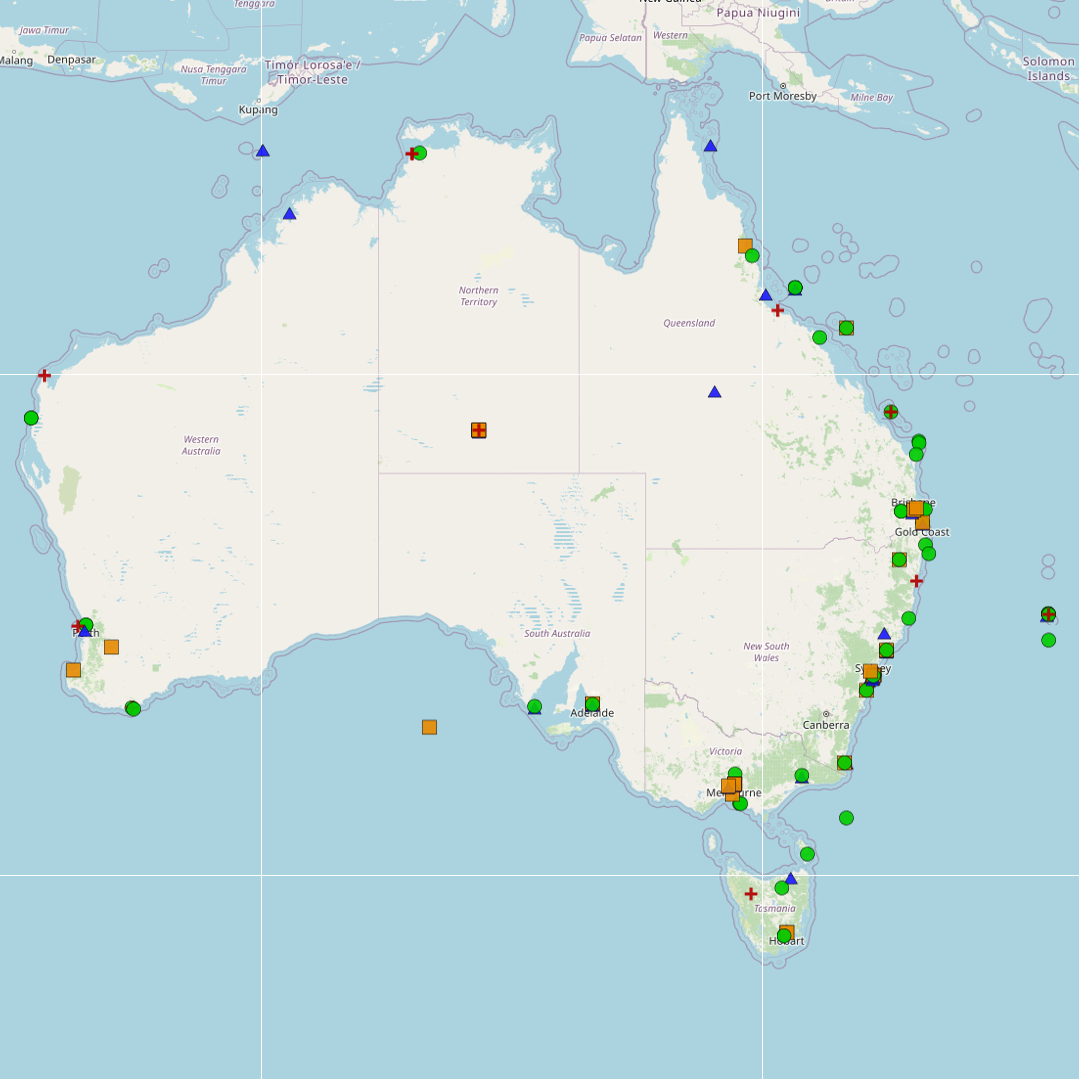
National Environmental Science Program (NESP) Marine and Coastal Hub
Type of resources
Topics
Keywords
Contact for the resource
Provided by
Years
-
A review of peer-reviewed publications was undertaken, focusing on coastal and marine microplastics relevant to South Eastern Australia (South Australia, Victoria, and New South Wales), as well as from ongoing citizen science programmes from AUSMAP. This dataset summarises basic information about the microplastics studies: the location of the study; if the study focused on water, sediment or biota; the type of biota (for biotic studies); and the DOI of the publication. Although the primary focus of this study was restricted to southeastern Australia, studies collated from other regions have also been included in this dataset. The outcomes of the literature review for other regions (QLD, NT, SA, WA, Tas) should not be considered comprehensive.
-

This metadata record provides a brief overview of the National Environmental Science Program (NESP) Marine and Coastal (MaC) Hub. The record acts as an aggregation point for all NESP Marine and Coastal Hub data collections and projects developed as part of this research program. The National Environmental Science Program (NESP) is a long-term commitment by the Australian Government to environment and climate research. The first phase invested $145 million (2014-15 to 2020-21) into 6 research hubs. The second phase invests $149 million (2020-21 to 2026-27) into 4 new research hubs. The program builds on its predecessors – the National Environmental Research Program (NERP) and the Australian Climate Change Science Programme (ACCSP) – to support decision-makers to understand, manage and conserve Australia’s environment by funding world-class biodiversity and climate science. The Marine and Coastal Hub is a collaborative partnership supported by funding from the Australian Government administered by the Department of Agriculture, Water and the Environment. The current NESP funding program runs from 2021 to 2027. The Marine and Coastal Hub is co-administered by the University of Tasmania (UTAS), and the Reef and Rainforest Research Centre (RRRC). The Marine and Coastal Hub will deliver: • applied research to support management of Australia’s marine and coastal environments including estuaries, coast, reefs, shelf and deep-water • targeted biodiversity and taxonomy products to support efficient system monitoring • environmental monitoring systems and decision-support tools. The hub will also drive coordinated research across all 4 new hubs under NESP’s ‘protected place management’ cross-cutting mission. This research will support management of Australia’s protected places and heritage, including the national park estate and Ramsar sites in both marine and terrestrial environments. Research products from the NESP Marine and Coastal Hub are available from https://nespmarinecoastal.edu.au and the Australian Ocean Data Network catalogue (http://catalogue.aodn.org.au)
-

This record provides an overview of the NESP Marine and Coastal Hub project "Advancing national standards and best practices to monitor key marine values and pressures". No data outputs are expected to be generated by this project. -------------------- This project aims to advance the establishment and use of national standards and best practices to monitor the condition status of priority values and pressures of Australia’s marine estate. It will build on the national standards and best practice process developed in the previous NESP Marine Biodiversity Hub to produce three new national standards for monitoring (drop cameras, socioeconomic surveys of marine users, marine microplastics). A practical implementation plan will be developed to embed the application of standards, with particular attention to inclusive and diverse approaches (e.g. engagement of community groups and Indigenous partnerships). The plan will set out a future path to develop, maintain and make available national standards; increase their uptake; and assess effectiveness and impact as related to the delivery of priority monitoring activities. Outputs • Workshop and questionnaire report gauging the needs of scientists, Indigenous communities, and marine managers [written] • Scientific publication on marine best practice development [written] • New national standards for (1) drop cameras; (2) socioeconomic surveys; and (3) microplastics studies [written] • Implementation plan (final report) [written] ---no data outputs will be generated by this project---
-
This record provides an overview of the NESP Marine and Coastal Hub project "Mapping temperate continental shelf seabed habitats". For specific data outputs from this project, please see child records associated with this metadata. -------------------- Rocky reefs provide anchors for attached marine invertebrate species such as corals and sponges, creating habitat for mobile invertebrates, and resident and roving fishes and mammals. They are subject to pressures from activities such as fishing, shipping, as well as climate change. Given their important natural, economic and social value, rocky reefs are focus areas for management in marine bioregional plans and Australian Marine Parks (AMPs). Previous collaborative research by the NESP Marine Biodiversity Hub and Parks Australia found that for many AMPs, understanding the extent of seabed habitats (including reef) is a priority for evaluating management effectiveness. While detailed habitat maps exists for many nearshore regions, however, they are lacking for Commonwealth waters. This project will fill gaps in knowledge of the extent and distribution of seabed habitats on Australia’s temperate continental shelf, with a focus on surveys of rocky reefs in the South-west Marine Parks Network and the South-east Marine Parks Network. Existing data will be collated and analysed to validate the presence/absence of seabed habitats on the temperate continental shelf, and drop cameras will be deployed at priority areas the validate habitats. The new knowledge will enhance the capacity of AMP managers to protect marine park values and assess the effectiveness of management. Outputs • Seafloor imagery and annotations [dataset] • Validated habitat maps (for AMPs with detailed observations) [dataset] • Habitat prediction maps (for AMPs lacking observations) [dataset] • Updated reef extent layer for temperate continental shelf [dataset] • Final technical report [written]
-

This record provides an overview of the NESP Marine and Coastal Hub Research Plan 2023 project "Assessing changes in black rockcod abundance and size". For specific data outputs from this project, please see child records associated with this metadata. -------------------- This project will assess the relative abundance and size of the threatened black rockcod (Epinephelus daemelii) to inform how the species is responding to conservation and management actions. In 2010, a broadscale survey (81 sites) was undertaken in northern NSW and Lord Howe Island, followed by subsequent surveys of a subset of these sites approximately every 4-5 years. This project proposes to repeat the surveys of the initial 81 baseline sites to assess if protection measures, such as marine protected area sanctuary zones, are assisting in recovery of black rockcod. Overall, this will provide a 13-year time series (2010 – 2023) that will be used to indicate if black rockcod are increasing in abundance, getting larger, and/or becoming more widespread, all indicators that can be used to assess if recovery actions being implemented are effective. Outputs • underwater visual census (UVC) data for black rock cod [dataset] • Final project report [written]
-

This record provides an overview of the NESP Marine and Coastal Hub project "Ecological outcomes of wastewater discharges in contrasting receiving environments". For specific data outputs from this project, please see child records associated with this metadata. -------------------- Australia’s Waste Policy Action Plan, Threat Abatement Plan for the impacts of marine debris and Australia’s One Health Master Action Plan all refer to the need for emerging pollutants to be incorporated into contaminant guidelines. Wastewater treatment plants currently report on a limited number of contaminants and lack consistent testing requirements. NESP MaC Scoping Study 1.16 has determined there is a clear and consistent need for data on environmental concentrations of emerging contaminants and an assessment of their impact on ecological communities. This project aims to determine the concentration of emerging pollutants in different wastewater outfall settings, and assess where environmental impacts are greatest. It will also continue to collate, analyse and maintain the information from Water Treatment Authorities on outfall flows, pollutant concentrations and loads and presented annually within the National Outfalls Database. Outputs • Measures of CEC (contaminants of emerging concern) in water samples taken from outfall sites [dataset] • Final project report [written]
-

This record provides an overview of the NESP Marine and Coastal Hub small-scale study - "Quantifying the ecosystem services of the Great Southern Reef". For specific data outputs from this project, please see child records associated with this metadata. -------------------- The Great Southern Reef (GSR) is an interconnected system of reefs dominated by kelp forests spanning over 8,000 km along southern Australia. It is a global hotspot for marine biodiversity and endemism, and one of the most productive ecosystems on Earth. Kelp forests, however, are diminishing and evidence-based management is hindered without accurate estimates of their contribution to society and the economy. In this project, we will systematically compile and synthesise existing data on the ecosystem values and services provided by the GSR, including market and non-market values. These assessments will be aligned with existing accounting standards to ensure compatibility with ongoing and future efforts. Outputs • Inventory of data collated and assessed for the purpose of developing ecosystem accounts for GSR • Final technical report with analysed data, including a short summary of recommendations for policy makers of key findings (written)
-
Tidal wetlands are vulnerable to accelerated rates of sea-level rise projected by climate models. The Surface Elevation Table (SET) is a technique applied globally to assess the extent of vertical adjustment of tidal wetlands to sea-level rise over decadal timescales. This record describes the SET data from the Australian network (OzSET). This data can be used for analyzing wetlands elevation change at the study sites
-
Fish annotations of stereo Baited Remote Underwater Video and panoramic drop camera imagery, were completed as part of a report funded by the NESP Marine & Coastal Hub. This report focussed on an IUCN II zone in the South-west Corner Marine Park off the 'Capes region' near Margaret River. These data were analysed in EventMeasure using standard operating procedures for the annotation of remote stereo imagery.
-
Benthic habitat annotations of stereo Baited Remote Underwater Video (Stereo-BRUV) and panoramic drop camera imagery, were completed as part of a report funded by the NESP Marine & Coastal Hub. This report focussed on an IUCN II zone in the South-west Corner Marine Park off the 'Capes region' near Margaret River. These data were analysed in TransectMeasure using a modified version of the CATAMI scheme.